Skip directly to site content Skip directly to page options Skip directly to A-Z link Skip directly to A-Z link Skip directly to A-Z link
Volume 22, Number 3—March 2016
Research

Faster Detection of Poliomyelitis Outbreaks to Support Polio Eradication

Isobel M. BlakeComments to Author , Paul Chenoweth, Hiro Okayasu, Christl A. Donnelly, R. Bruce Aylward, and Nicholas C. Grassly
Author affiliations: Imperial College London, London, UK (I.M. Blake, C.A. Donnelly, N.C. Grassly); World Health Organization, Geneva, Switzerland (P. Chenoweth, H. Okayasu, R.B. Aylward)

Main Article

Figure 1

Nonpolio acute flaccid paralysis (AFP) cases in sub-Saharan Africa, 2003–2013. Left, mean annual number of cases reported at the second administrative unit (district) in countries in sub-Saharan Africa that have recently experienced a polio importation or outbreak or are considered to be at high risk for these events. Right, expected annual number of nonpolio acute flaccid paralysis cases reported at the district level; the number was obtained by fitting a spatiotemporal mixed-effects regression

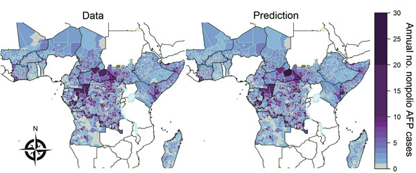
Figure 1. Nonpolio acute flaccid paralysis (AFP) cases in sub-Saharan Africa, 2003–2013. Left, mean annual number of cases reported at the second administrative unit (district) in countries in sub-Saharan Africa that have recently experienced a polio importation or outbreak or are considered to be at high risk for these events. Right, expected annual number of nonpolio acute flaccid paralysis cases reported at the district level; the number was obtained by fitting a spatiotemporal mixed-effects regression model to nonpolio AFP data from 2003–2013. Areas that report >25 annual cases are grouped into the 25–30 category (the maximum observed annual reported number was 128 in Tshopo, Democratic Republic of the Congo, in 2007). South Sudan gained independence in 2011, but reporting in this area before independence is shown for comparison. The publication of these maps does not imply the expression of any opinion whatsoever on the part of the World Health Organization (WHO) concerning the legal status of any territory, city, or area or of its authorities or concerning the delimitation of its frontiers or boundaries. WHO does not endorse or approve the use of subnational boundaries in this map. Disputed borders and areas are shown in green and lakes at borders are shown in pale blue.

Main Article

Page created: February 18, 2016
Page updated: February 18, 2016
Page reviewed: February 18, 2016
The conclusions, findings, and opinions expressed by authors contributing to this journal do not necessarily reflect the official position of the U.S. Department of Health and Human Services, the Public Health Service, the Centers for Disease Control and Prevention, or the authors' affiliated institutions. Use of trade names is for identification only and does not imply endorsement by any of the groups named above.
file_external