Volume 14, Number 8—August 2008
Letter
Improving Methods for Reporting Spatial Epidemiologic Data
A. Townsend Peterson*
Figure
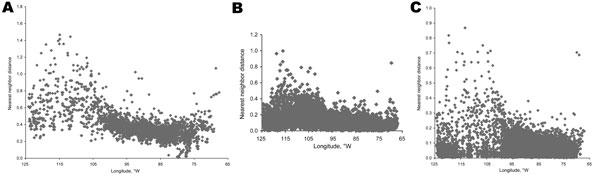
Figure. Longitudinal patterns in nearest-neighbor distances for A) counties, B) ZIP codes, and C) census tracts across the lower 48 United States, showing trends toward greater spacing among districts in the western United States compared with the eastern United States in all 3 regionalizations.
Page created: July 13, 2010
Page updated: July 13, 2010
Page reviewed: July 13, 2010
The conclusions, findings, and opinions expressed by authors contributing to this journal do not necessarily reflect the official position of the U.S. Department of Health and Human Services, the Public Health Service, the Centers for Disease Control and Prevention, or the authors' affiliated institutions. Use of trade names is for identification only and does not imply endorsement by any of the groups named above.