Volume 30, Number 10—October 2024
Research Letter
Spatiotemporal Epidemiology of Oropouche Fever, Brazil, 2015–2024
Figure 1
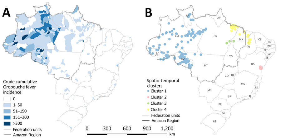
Figure 1. Spatiotemporal maps of epidemiology of Oropouche fever, Brazil, 2015–2024. A) Cumulative incidence (cases per 100,000 inhabitants); B) high-risk spatiotemporal clusters identified across municipalities. AC, Acre; AL, Alagoas; AM, Amazonas; AP, Amapá; BA, Bahia; CE, Ceará; DF, Federal District; ES, Espírito Santo; GO, Goiás; MA, Maranhão; MG, Minas Gerais; MS, Mato Grosso do Sul; MT, Mato Grosso; PA, Pará; PB, Paraíba; PE, Pernambuco; PI, Piauí; PR, Paraná; RJ, Rio de Janeiro; RN, Rio Grande do Norte; RO, Rondônia; RR, Roraima; RS, Rio Grande do Sui; SC, Santa Catarina; SE, Sergipe; SP, São Paulo; TO, Tocantins.
Page created: August 28, 2024
Page updated: September 24, 2024
Page reviewed: September 24, 2024
The conclusions, findings, and opinions expressed by authors contributing to this journal do not necessarily reflect the official position of the U.S. Department of Health and Human Services, the Public Health Service, the Centers for Disease Control and Prevention, or the authors' affiliated institutions. Use of trade names is for identification only and does not imply endorsement by any of the groups named above.