Skip directly to site content Skip directly to page options Skip directly to A-Z link Skip directly to A-Z link Skip directly to A-Z link
Volume 24, Number 6—June 2018
Research

Widespread Treponema pallidum Infection in Nonhuman Primates, Tanzania

Idrissa S. Chuma, Emmanuel K. Batamuzi1, D. Anthony Collins, Robert D. Fyumagwa, Luisa K. Hallmaier-Wacker, Rudovick R. Kazwala, Julius D. Keyyu, Inyasi A. Lejora, Iddi F. Lipende, Simone Lüert, Filipa M.D. Paciência, Alexander Piel, Fiona A. Stewart, Dietmar Zinner, Christian Roos, and Sascha KnaufComments to Author 
Author affiliations: Sokoine University of Agriculture, Morogoro, Tanzania (I.S. Chuma, E.K. Batamuzi, R.R. Kazwala, I.F. Lipende); German Primate Center, Leibniz-Institute for Primate Research, Göttingen, Germany (I.S. Chuma, L.K. Hallmaier-Wacker, S. Lüert, F.M.D. Paciência, D. Zinner, C. Roos, S. Knauf); Jane Goodall Institute, Kigoma, Tanzania (D.A. Collins); Tanzania Wildlife Research Institute, Arusha, Tanzania (R.D. Fyumagwa, J.D. Keyyu); Tanzania National Parks, Arusha (I.A. Lejora); Liverpool John Moores University, Liverpool, UK, and Greater Mahale Ecosystem Research and Conservation Project, Kigoma (A. Piel, F.A. Stewart)

Main Article

Figure 1

Protected areas and sites where free-ranging nonhuman primates (NHPs) were sampled in a study of Treponema pallidum infection, Tanzania. 1, Serengeti National Park (41 NHPs); 2, Ngorongoro Conservation Area (18 NHPs) 3, Lake Manyara National Park (38 NHPs); 4, Tarangire National Park (26 NHPs); 5, Arusha National Park (14 NHPs); 6, Gombe National Park (32 NHPs); 7, Mahale National Park (17 NHPs); 8, Issa valley (2 NHPs); 9, Katavi National Park (12 NHPs); 10, Ruaha National Park (18 NHPs); 11, U

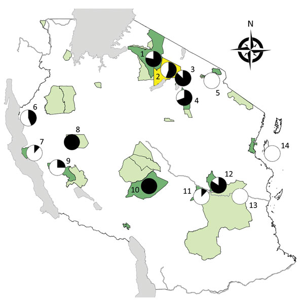
Figure 1. Protected areas and sites where free-ranging nonhuman primates (NHPs) were sampled in a study of Treponema pallidum infection, Tanzania. 1, Serengeti National Park (41 NHPs); 2, Ngorongoro Conservation Area (18 NHPs) 3, Lake Manyara National Park (38 NHPs); 4, Tarangire National Park (26 NHPs); 5, Arusha National Park (14 NHPs); 6, Gombe National Park (32 NHPs); 7, Mahale National Park (17 NHPs); 8, Issa Valley (2 NHPs); 9, Katavi National Park (12 NHPs); 10, Ruaha National Park (18 NHPs); 11, Udzungwa National Park (25 NHPs); 12, Mikumi National Park (25 NHPs); 13, Selous Game Reserve (8 NHPs); 14, Jozani-Chwaka Bay National Park–Masingini Forest on Unguja Island, Zanzibar (13 NHPs). Dark green indicates national parks; light green indicates game reserves; yellow indicates conservation area. Circle graphs: black, NHPs T. pallidum–positive (serology and/or PCR); white, NHPs T. pallidum–negative (serology and PCR). The map was produced with ArcMap version 10.0 (ESRI, Redlands, CA, USA) by using shape files available from ESRI (national boundary of Tanzania, water bodies of Africa, main rivers of Africa). The shape files of the conservation areas of Tanzania were provided by the Tanzania National Park Authority and are available free from http://www.arcgis.com/home/item.html?id = 9b06fe723ad14991b30b1b85953224c1. Prevalence circles were generated using Excel version 15.38 (Microsoft, Redmond, WA, USA).

Main Article

1Deceased.

Page created: May 17, 2018
Page updated: May 17, 2018
Page reviewed: May 17, 2018
The conclusions, findings, and opinions expressed by authors contributing to this journal do not necessarily reflect the official position of the U.S. Department of Health and Human Services, the Public Health Service, the Centers for Disease Control and Prevention, or the authors' affiliated institutions. Use of trade names is for identification only and does not imply endorsement by any of the groups named above.
file_external