Volume 6, Number 3—June 2000
Perspective
Remote Sensing and Human Health: New Sensors and New Opportunities
Figure 2
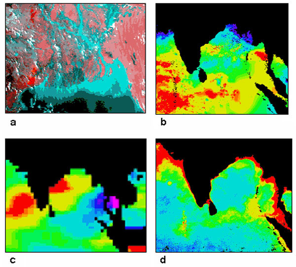
Figure 2. Datasets used to model the temporal patterns of cholera outbreaks in Bangladesh. a) Advanced Very High Resolution Radiometer (AVHRR) satellite image showing the mouth of the Ganges River and the Bay of Bengal. Vegetation is shown in shades of red and water in shades of blue. The spatial resolution of these data is 1.1 km. b) Sea surface temperature data, derived from AVHRR thermal bands. Temperatures range from low (purple) to high (red). c) Sea surface height data, derived from TOPEX/Poseidon satellite data. The spatial resolution of these data is 1 degree. d) Image derived from the Sea-viewing Wide Field-of-view Sensor (SeaWiFS) showing chlorophyll concentration, ranging from low (blue) to high (red). These satellite data have a nominal spatial resolution of 1.1 km.
1CHAART was established at Ames Research Center by NASA's Life Sciences Division, within the Office of Life & Microgravity Sciences & Applications, to make remote sensing, geographic information systems, global positioning systems, and computer modeling available to investigators in the human health community.
2The information gathered during the CHAART sensor evaluation process is available at http://geo.arc.nasa.gov/sge/health/sensor/sensor.html.