Volume 20, Number 8—August 2014
Research
Human Exposure to Live Poultry and Psychological and Behavioral Responses to Influenza A(H7N9), China
Figure 1
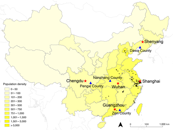
Figure 1. Geographic distribution of urban locations (red stars) and rural locations (blue triangles) selected for population survey to determine human exposure to live poultry and attitudes and behavior toward influenza A(H7N9) in China, 2013Black dots indicate geographic locations of laboratory-confirmed cases of H7N9 through October 31, 2013Shading indicates population density (persons per square kilometer)The 5 selected urban locations were Chengdu, capital of Sichuan Province in western China, population 10 million; Guangzhou, capital of Guangdong Province in southern China, population 13 million; Shanghai, a municipality in eastern China, population 23 million; Shenyang, capital of Liaoning Province in northeastern China, population 8 million; and Wuhan, capital of Hubei Province in central China, population 10 millionThe 4 rural areas were Dawa County (Panjin city, Liaoning Province), Zijin County (Heyuan city, Guangdong Province), Nanzhang County (Xiangfan city, Hubei Province), and Pengxi County (Suining city, Sichuan Province).
1These authors contributed equally to this article.