Volume 23, Number 4—April 2017
Research Letter
Peste des Petits Ruminants Virus in Vulnerable Wild Small Ruminants, Iran, 2014–2016
Mahmoud Marashi, Siamak Masoudi, Majid Kharazian Moghadam, Hossein Modirrousta, Mahyar Marashi, Masoumeh Parvizifar, Majid Dargi, Mahyar Saljooghian, Farbod Homan, Bernd Hoffmann, Claudia Schulz, Elke Starick, Martin Beer, and Sasan Fereidouni
Figure
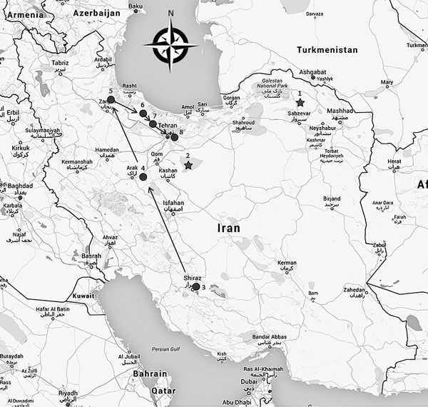
Figure. Geographic distribution of peste des petits ruminants virus outbreaks in Iran since 2000. Stars indicate outbreaks that occurred in 2000 and 2011; circles indicate outbreaks investigated during this study in 2014–2016. Arrows indicate chronologic order of the outbreaks: 1, Sarigol National Park; 2, Kavir National Park; 3, Bamou National Park; 4, Haftad-qolleh; 5, Kharmaneh Sar Tarom; 6, Alamout Protected Area; 7, Taleghan Protected Area; 8, Khojir National Park. Map generated using Google Maps (interactive map available at https://www.google.com/maps/d/viewer?mid=1GsluO7SZ2z_SBUawdPHsDF6s7ww). Details on the number of animals and dates of outbreaks are available in the Technical Appendix.
Page created: March 16, 2017
Page updated: March 16, 2017
Page reviewed: March 16, 2017
The conclusions, findings, and opinions expressed by authors contributing to this journal do not necessarily reflect the official position of the U.S. Department of Health and Human Services, the Public Health Service, the Centers for Disease Control and Prevention, or the authors' affiliated institutions. Use of trade names is for identification only and does not imply endorsement by any of the groups named above.