Ecologic, Geoclimatic, and Genomic Factors Modulating Plague Epidemics in Primary Natural Focus, Brazil
Matheus F. Bezerra

, Diego L.R.S. Fernandes, Igor V. Rocha, João L.L.P. Pitta, Natan D.A. Freitas, André L.S. Oliveira, Ricardo J.P.S. Guimarães, Elainne C.S. Gomes, Cecília Siliansky de Andreazzi, Marise Sobreira, Antonio M. Rezende, Pedro Cordeiro-Estrela, and Alzira M.P. Almeida
Author affiliations: Instituto Aggeu Magalhães, Fiocruz, Brazil (M.F. Bezerra, D.L.R.S Fernandes, I.V. Rocha, J.L.L.P. Pitta, E.C.S. Gomes, M. Sobreira, A.M. Rezende, A.M.P. Almeida); Laboratório de Mamíferos, Pós Graduação em Ciências Biológicas (Zoologia), Universidade Federal da Paraíba, João Pessoa, Brazil (N.D.A. Freitas, P. Cordeiro-Estrela); Núcleo de Geoprocessamento, Instituto Aggeu Magalhães, Fiocruz (A.L.S. Oliveira); Laboratório de Geoprocessamento, Instituto Evandro Chagas, Belém, Brazil (R.J.P.S. Guimarães); Laboratório de Biologia e Parasitologia de Mamíferos Silvestres Reservatórios, Instituto Oswaldo Cruz, Fiocruz, Rio de Janeiro, Brazil (C.S. de Andreazzi); Universidad Complutense de Madrid, Madrid, Spain (C.S. de Andreazzi); International Platform for Science, Technology and Innovation in Health, PICTIS, Ílhavo, Portugal (C.S. de Andreazzi); Group of Biotechnology Applied to Pathogens, René Rachou Institute, Fiocruz (A.M. Rezende)
Main Article
Figure 1
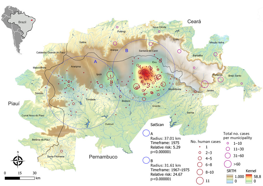
Figure 1. Spatial distribution and risk analysis of human plague cases in a study of ecologic, geoclimatic, and genomic factors modulating plague epidemics in primary natural focus, Brazil. Background colors show the altimetry (m) from SRTM. The black line shows the tri-state boundaries between Pernambuco, Ceará, and Piauí. Red circles identify plague risk areas by application of KDE in human cases in Pernambuco. Blue circles A and B indicate plague risk clusters calculated by SaTScan for 1975 (A) and 1967–1975 (B). Pink circles indicate spatial distribution of human plague cases by number of occurrences per municipality in Ceará. Inset map shows Brazil with the Araripe Plateau focus in red. KDE, kernel density estimation; SaTScan, space-time scan (https://www.satscan.org) statistics; SRMT, Shuttle Radar Topography Mission (https://www.earthdata.nasa.gov).
Main Article
Page created: July 11, 2024
Page updated: August 22, 2024
Page reviewed: August 22, 2024
The conclusions, findings, and opinions expressed by authors contributing to this journal do not necessarily reflect the official position of the U.S. Department of Health and Human Services, the Public Health Service, the Centers for Disease Control and Prevention, or the authors' affiliated institutions. Use of trade names is for identification only and does not imply endorsement by any of the groups named above.