Skip directly to site content Skip directly to page options Skip directly to A-Z link Skip directly to A-Z link Skip directly to A-Z link

Disclaimer: Early release articles are not considered as final versions. Any changes will be reflected in the online version in the month the article is officially released.

Volume 32, Number 5—May 2026

Research Letter

Borrelia turicatae in Ticks from Animals in a Public Park, Aguascalientes, Mexico

Edwin Vázquez-Guerrero1, Gustavo Paniagua-Campos1, Alexander R. Kneubehl, Paulina Estrada de los Santos, Job E. Lopez, and J. Antonio IbarraComments to Author 
Author affiliation: Instituto Politécnico Nacional, Mexico City, Mexico (E. Vázquez-Guerrero, G. Paniagua-Campos, P. Estrada-de los Santos, J.A. Ibarra); Baylor College of Medicine, Houston, Texas, USA (A.R. Kneubehl, J.E. Lopez)

Main Article

Figure 1

Locations of collection sites in study of Borrelia turicatae in ticks from animals in a public park, Aguascalientes, Mexico. A) Location of the state of Aguascalientes (black shading) in Mexico; inset at right shows the approximate location of the city of Aguascalientes (black dot). Map created using QGIS version 3.34 (https://qgis.org). B) Terrain map of La Pona Park in Aguascalientes. Green dots indicate collection sites where ticks were captured (SITAG01–07, 21°53′10.6” N 102°15′59.6” W; 21°53′13.4” N 102°16′01.7” W; 21°53′12.5” N 102°16′02.1” W; 21°53′18.2” N 102°16′06.6” W; 21°53′20.9” N 102°15′51.5” W; 21°53′11.1” N 102°16′03.1” W). Red dots indicate the 3 collection sites for resident fauna (SITAG08, 21°53′18” N, 102°16′00” W; SITAG09, 21°53′19” N, 102°15′57” W; SITAG10, 21°53′16” N, 102° 16′ 07” W). Map created using the ArcGIS imagery basemap (https://services.arcgisonline.com/ArcGIS/rest/services/World_Imagery/MapServer).

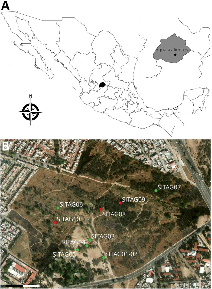
Figure 1. Locations of collection sites in study of Borrelia turicatae in ticks from animals in a public park, Aguascalientes, Mexico. A) Location of the state of Aguascalientes (black shading) in Mexico; inset at right shows the approximate location of the city of Aguascalientes (black dot). Map created using QGIS version 3.34 (https://qgis.org). B) Terrain map of La Pona Park in Aguascalientes. Green dots indicate collection sites where ticks were captured (SITAG01–07, 21°53′10.6” N 102°15′59.6” W; 21°53′13.4” N 102°16′01.7” W; 21°53′12.5” N 102°16′02.1” W; 21°53′18.2” N 102°16′06.6” W; 21°53′20.9” N 102°15′51.5” W; 21°53′11.1” N 102°16′03.1” W). Red dots indicate the 3 collection sites for resident fauna (SITAG08, 21°53′18” N, 102°16′00” W; SITAG09, 21°53′19” N, 102°15′57” W; SITAG10, 21°53′16” N, 102° 16′ 07” W). Map created using the ArcGIS imagery basemap (https://services.arcgisonline.com/ArcGIS/rest/services/World_Imagery/MapServer).

Main Article

1These authors contributed equally to this article.

Page created: April 13, 2026
Page updated: April 28, 2026
Page reviewed: April 28, 2026
The conclusions, findings, and opinions expressed by authors contributing to this journal do not necessarily reflect the official position of the U.S. Department of Health and Human Services, the Public Health Service, the Centers for Disease Control and Prevention, or the authors' affiliated institutions. Use of trade names is for identification only and does not imply endorsement by any of the groups named above.
file_external