Volume 7, Number 5—October 2001
Research
Factors Contributing to the Emergence of Escherichia coli O157 in Africa
Paul Effler* , Margaretha Isaäcson†, Lorraine Arntzen†, Rosemary Heenan‡, Paul Canter§, Timothy Barrett*, Lisa Lee*, Clifford Mambo§, William Levine*, Akbar Zaidi*, and Patricia M. Griffin*
Figure 1
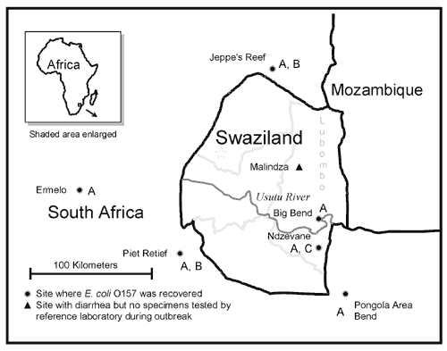
Figure 1. . Map of the area affected by an outbreak of diarrheal illness in 1992.a aPulsed-field gel electrophoresis of 31 of the Escherichia coli O157:NM isolates from six locations identified three distinct patterns, designated A, B and C; the locations where these isolates were obtained are indicated on the map by the corresponding letter. Not shown on the map is Empangeni, South Africa, located approximately 200 km south of Swaziland border, where E. coli O157 was also recovered. The Usutu River is also called the Lusutfu River.
Page created: April 26, 2012
Page updated: April 26, 2012
Page reviewed: April 26, 2012
The conclusions, findings, and opinions expressed by authors contributing to this journal do not necessarily reflect the official position of the U.S. Department of Health and Human Services, the Public Health Service, the Centers for Disease Control and Prevention, or the authors' affiliated institutions. Use of trade names is for identification only and does not imply endorsement by any of the groups named above.