Skip directly to site content Skip directly to page options Skip directly to A-Z link Skip directly to A-Z link Skip directly to A-Z link
Volume 30, Number 12—December 2024
Research

Dogs as Reservoirs for Leishmania donovani, Bihar, India, 2018–2022

Anurag Kumar Kushwaha1, Ashish Shukla1, Breanna M. Scorza, Rahul Chaubey, Dharmendra Kumar Maurya, Tulika Kumari Rai, Shyamali Yaduvanshi, Shweta Srivastava, Gaetano Oliva, Epke A. Le Rutte, Rajiv Kumar, Om Prakash Singh, Puja Tiwary, Shakti Kumar Singh, Scott A. Bernhardt, Phillip Lawyer, Edgar Rowton, Christine A. Petersen1Comments to Author , and Shyam Sundar1
Author affiliation: Banaras Hindu University, Varanasi, India (A.K. Kushwaha, A. Shukla, D.K. Maurya, T.K. Rai, S. Yaduvanshi, S. Srivastava, R. Kumar, O.P. Singh, P. Tiwary); University of Iowa, Iowa City, Iowa, USA (B.M. Scorza, C.A. Petersen); Kala-Azar Medical Research Center, Muzaffarpur, India (R. Chaubey, S. Sundar); University of Naples Federico II, Naples, Italy (G. Oliva), Swiss Tropical and Public Health Institute, Basel, Switzerland (E.A. Le Rutte); National Museum of Natural History, New Delhi, India (S.K. Singh); Utah State University, Logan, Utah, USA (S.A. Bernhardt); Walter Reed Army Institute for Research, Silver Spring, Maryland, USA (P. Lawyer, E. Rowton)

Main Article

Figure 1

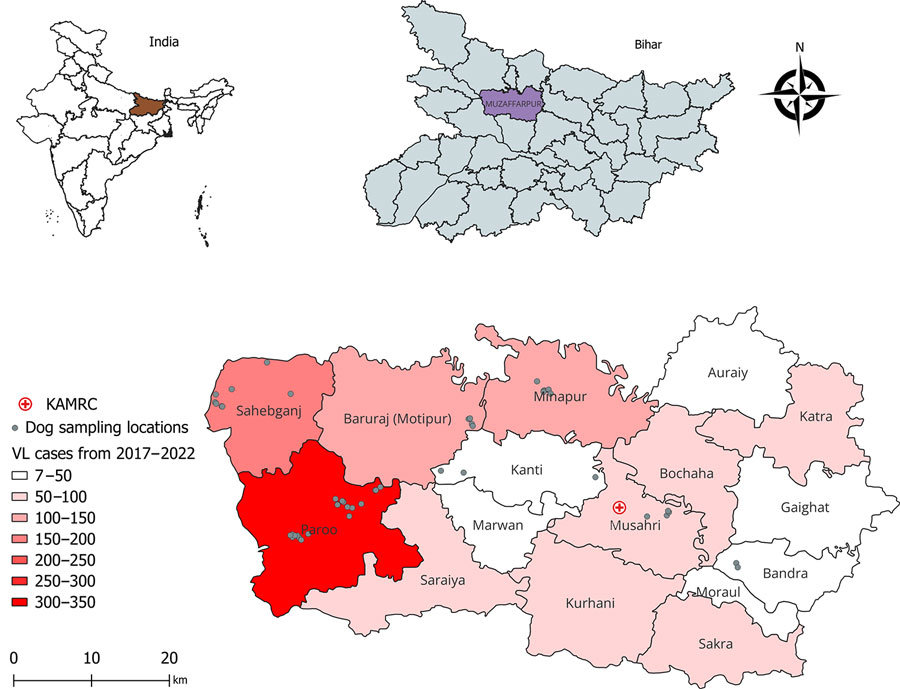
Locations of study villages and 5-year incidence of VL in a study of dogs as reservoirs for Leishmania donovani, Bihar, India, 2018–2022. A) Map of India showing Bihar; B) Bihar detail showing Muzaffarpur district study area; C) detail of sampling locations and VL cases, Muzaffarpur district. Geographic information system locations of study sampling sites calculated from a latitude-longitude application. Map produced using QGIS software version 3.30.3 (https://qgis.org) with open-access shapefile (https://onlinemaps.surveyofindia.gov.in). KAMRC, Kala-Azar Medical Research Center.

Figure 1. Locations of study villages and 5-year incidence of VL in a study of dogs as reservoirs for Leishmania donovani, Bihar, India, 2018–2022. A) Map of India showing Bihar; B) Bihar detail showing Muzaffarpur district study area; C) detail of sampling locations and VL cases, Muzaffarpur district. Geographic information system locations of study sampling sites calculated from a latitude-longitude application. Map produced using QGIS software version 3.30.3 (https://qgis.org) with open-access shapefile (https://onlinemaps.surveyofindia.gov.in). KAMRC, Kala-Azar Medical Research Center.

Main Article

1These authors contributed equally to this article.

Page created: October 30, 2024
Page updated: November 26, 2024
Page reviewed: November 26, 2024
The conclusions, findings, and opinions expressed by authors contributing to this journal do not necessarily reflect the official position of the U.S. Department of Health and Human Services, the Public Health Service, the Centers for Disease Control and Prevention, or the authors' affiliated institutions. Use of trade names is for identification only and does not imply endorsement by any of the groups named above.
file_external